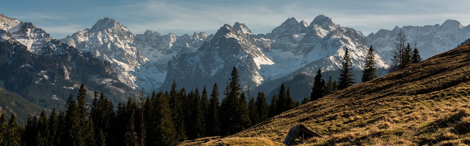
Here, thanks to Stanisław Witkiewicz, the unique Zakopane style in architecture was born. The town at the foot of the romantic Tatra Mountains was the quintessence of the Young Polish art and poetry. Jan Kasprowicz, Kazimierz Przerwa-Tetmajer and the versatile Witkacy were active here. Join us to see the Tatra valleys and flowery meadows. You will wander across river valleys, among the Tatra lakes, through forests full of beech, fir, spruce and sycamore trees. You will hear the wind howling in rocks and cragged peaks, telling stories about robbers and dreamers. You will taste the sheep cheese straight from highlander farmers and find out how life in the wild Carpathians looked like. Join us for poetic micro-trips with your family and friends in the spirit of eco-ethno-tourism.
SUGGESTED TOURS:
1. Following the Traces of Glaciers
Palenica Białczańska – Białka Valley – Roztoka Valley – Wielka Siklawa Waterfall –PTTK Refuge in the Valley of Five Polish Ponds – Morskie Oko – Palenica Białczańska
The trip starts at Palenica Białczańska. You can get here with public transportation from Zakopane and in the summer season also from other locations. If you decide to come by car, definitely reserve the parking site 1-2 days in advance via: www.tpn.pl.
The first part of the route leads across the lower section of the Białka Valley, which is the largest Tatra valley with a surface area of over 60 km2. The largest Tatra glacier was located here in the Pleistocene. Today, we set off to find its traces. After 600 m, we go across a bridge on the Waksmundzki Brook, which flows into the Białka right below. At this section, the river forms a border between Poland and Slovakia, dividing the Podhale and the Spiš regions and two Tatra national parks – the Polish and the Slovakian one. The name of the river derives from the white pebbles filling its bed. Further, we can admire views of the upper part of the Białka Valley, i.e., the Slovakian White Water Valley (Dolina Białej Wody) with the characteristic U-shaped cross-cut, which is a remnant of the glacier terminus that used to fill it. The valley is dominated by the massive silhouette of Mount Gerlach – the highest peak in the Tatra Mountains (2,655 m a.s.l.).
2.8 km: from the bridge, we can admire the Mickiewicz Waterfalls (Wodogrzmoty Mickiewicza) – a series of waterfalls on the Roztoka Brook, which were created in a place where the Roztoka Valley is suspended above the Białka Valley. The main valley is indented, because the larger – and thus heavier – terminus of the glacier was located here. We leave the asphalt road, turn right and wander along the green trail at the bottom of the Roztoka Valley. It is surrounded on both sides by steep, rocky slopes overgrown with precipice forests. In the gullies, the tree line has been lowered on account of avalanches.
7.4 km: we pass by the largest waterfall in the Polish Tatra Mountains – the Wielka Siklawa, which falls from the threshold of Valley of Five Polish Ponds (Dolina Pięciu Stawów Polskich). The height of the waterfall is over 70 m. Above the Siklawa Waterfall, we walk on glacial polish, which was created by the fragments of rocks transported in the body of the glacier rubbing against the ground. After a while, we enter a place where the Roztoka Brook flows out of the Great Polish Pond (Wielki Staw Polski). This is the deepest Tatra lake (79 m) and one of the largest (34 km2). The basin of the lake was sculpted by the snouts of glaciers that were united here. The Kozi Wierch massif towers on the right. We turn left and follow the blue signs to the mountain refuge, passing two more ponds along the way: Mały and Przedni (the Tatra lakes are called ponds).
8.2 km: the PTTK Mountain Refuge in the Valley of Five Polish Ponds is located at the height of 1,671 m a.s.l. and is the highest mountain refuge in Poland. The first mountain refuge was built here in 1876. The present-day building was opened in 1953. From the mountain refuge, we go to the ridge of Opalony Wierch (this is the highest point of our route, 1,855 m a.s.l.) and walk down to Świstówka Roztocka, a small valley suspended above the Roztoka Valley. Further, amidst mountain pines, we reach a plane called Wolarnia with a beautiful view to Dolina Rybiego Potoku, with Żabie Szczyty and Mięguszowieckie Szczyty towering above it, and between them, the highest peak in the Polish part of the Tatras – Mount Rysy (2,499 m a.s.l.). We get to the bottom of the valley, traversing gullies that are engulfed in avalanches in wintertime. There are relic Arolla pine forests in the upper forest line. We reach the asphalt road where the blue trail ends.
12.3 km: Morskie Oko (1,395 m a.s.l.) – the largest Tatra lake and the most popular site in the Tatra Mountains among tourists. Similarly to the Great Polish Pond (Wielki Staw Polski), it came into being in a place where several glaciers flowing down from the upper sections of the valley converged. The landscape of the lake, surrounded by rock walls that are several hundred metres high, attracts even many thousands of people per day in the high season. This was the only lake in the Polish Tatras that was naturally restocked with fry and in the past it was known as the Fish Pond (Rybi Staw). People used to believe that it had an underground connection with the sea, thence its name (Morskie Oko – the Eye of the Sea). The PTTK Mountain Refuge at Morskie Oko is the oldest refuge on the Polish side of the Tatra Mountains. It was opened in 1908.
Along the asphalt road, we return to Palenica Białczańska. In the area of Wanta, the trail leads along shortcuts between the serpentine turns of the road. Here, you can see large rocks left by the glacier, in the highlander dialect called ‘wanty’.
2. Nad Reglami
The Nature Education Centre of the Tatra National Park ˗ Wielka Krokiew ˗ Educational Path of Stanisław Sokołowski – Ścieżka nad Reglami – Kalatówki Clearing – Kuźnice
The trip starts at the Nature Education Centre of the Tatra National Park in Zakopane (Centrum Edukacji Przyrodniczej Tatrzańskiego Parku Narodowego) at 42 Chałubińskiego Street. Here, you can see a modern multi-media display which offers a good background for the trip. There is no admission fee. However, you have to book in advance on www.tpn.pl.
We reach the Great Krokiew (Wielka Krokiew) ski jumping hill along Bronisława Czecha Street and arrive at Droga Pod Reglami (black trail), which connects the exits of the valleys and is a popular destination for strollers. At the end of the 18th and the first half of the 19th century it was used for the transportation of iron ores from the mines in the Kościeliska Valley to the ironworks in Kuźnice. We are at the geological border of the Tatra Mountains: on the right hand side, we can admire a view of the Zakopane Valley and the Gubałowskie Foothills.
1.7 km: outlet of the Biały Valley. Next to the ticket office of the Tatra National Park, we take a turn and follow the yellow trail. The Educational Path of Stanisław Sokołowski starts here. We walk at the bottom of a valley which forms a narrow gorge here. In the bed of the brook are a sequence of thresholds with cascades of water flowing and creating plunge pools, which are gradually deepened by the whirling water. Slopes made of limestone and dolomites are the habitats for rock vegetation. Higher up, we pass by an opening of a drift from the 1950s – these are remnants of uranium ore prospecting in the Tatra Mountains. Further up, we can admire a beautifully preserved Carpathian beech forest, which used to be the most numerous forest complex in the lower montane zone. The forest comprises beech, fir, spruce and sycamore trees. In the springtime, geophytes blossom in the undergrowth: coral-foot bittercress, anemones and primroses, while in the summer, we can admire several species of orchids here.
4.3 km: we reach the Ścieżka nad Reglami marked in black and follow it to the left. We pass by a fragment of a spruce forest where a change in generations of trees can be observed: the old growth was attacked by the bark beetle a few years ago and now a new generation of trees is starting to grow here. Further, the path traverses steep gullies and we go across several wooden bridges. Here, the upper forest line has been lowered due to the lay of the land and avalanches which occur in the wintertime. The rocks are overgrown with dwarf mountain pine and Arolla pines. Through Przełęcz Białego we reach the Bystra Valley (Dolina Bystrej).
7.1 km: the Kalatówki Clearing (Polana Kalatówki) with a view to Kasprowy Wierch. In the summer, the so-called ‘cultural’ grazing of sheep and cows is carried out here and thanks to this, in the spring we can admire a carpet of several million crocus flowers. From Kalatówki we walk towards Kuźnice. Along the way, we pass by the buildings of Albertine nunnery. The historical chapel and the hermitage of Brother Albert are open for visitors. In 1997, this place was visited by St John Paul II.
8.7 km: we reach Kuźnice next to the lower station of the funicular to Kasprowy Wierch. We can end the trip here and can get on one of the buses that regularly travel to the centre of Zakopane or walk along Aleja Przewodników Tatrzańskich to the place where we started our journey.
In Zakopane, we can stroll and search for the traces of Zakopane style buildings; this style was created by Stanisław Witkiewicz, an outstanding painter, architect and writer (father of Witkacy). Most examples of such architecture have been preserved at Kościeliska Street. The Museum of Zakopane Style was set up in Villa Koliba at No. 18.
3. Underground Kościeliska
Outlet of Kościeliska Valley (Kościelisko - Kiry) – Wyżnia Kira Miętusia –Stare Kościeliska Clearing – Pośrednia Brama Kościeliska – Brama Krakowska – Kiry
We set off from the outlet of Kościeliska Valley (Dolina Kościeliska) (Kościelisko – Kiry) on the green trail. Right behind the TPN ticket office is the Kantaka Gate (Brama Kantaka), first of three rock gates in the valley. It is made of crinoidal limestone where the Kościeliski Brook managed to sculpt a narrow gorge. On the left hand side, we can see an opening of the research shaft from the inter-war period when a plan was prepared to build a water dam here.
0.5 km: the Wyżnia Kira Miętusia spreads behind the gate, with a shepherd's hut. It is one of four clearings where the so-called ‘cultural’ grazing of sheep and cows in the valley is carried out. On the slopes of Kościeliskie Kopki on the right hand side of the valley is a windfall from December 2013. Hurricane-force winds destroyed the spruce forest planted here almost entirely. As part of forest recovery projects, new generation trees were planted here, this time in observance of the rules of the habitat, i.e., a mixed forest with beech, fir, spruce and sycamore trees. Behind the bridge is Cudakowa Clearing (Cudakowa Polana) with a group of old sycamore trees. Their bark is covered with a rich layer of lichen, including beard lichens, which testify to the high quality of air.
1.8 km: the Stare Kościeliska Clearing (Polana Stare Kościeliska) with remnants of a mining and metallurgical centre that operated here in the 18th and the 19th century. The remnants include a mining wayside shrine and fragments of foundations of a metallurgical oven. An old linden tree and a group of common maples grow on the clearing. At the end of the clearing, we can go across a bridge and see the Ice Spring (Lodowe Źródło) from up close –it is one of the largest karst springs in the Tatra Mountains. It drains a significant portion of the Czerwone Wierchy massif, among others the largest cave in the Tatras, Wielka Śnieżna. The water has a fixed temperature of 4–4.5 ºC. Next to it is a trail to the Frosty Cave (Jaskinia Mroźna), which has been closed due to the renovation of the trail (planned opening is scheduled for spring 2023).
2.5 km: we pass another rock gate known as Pośrednia Brama Kościeliska or Bramka Kraszewskiego. Steep slopes are covered with precipice forests and rock vegetation, among others edelweiss. Here, we can also see a bird that inhabits the areas close to mountain brooks – the white-throated dipper. The valley becomes wider again and its bottom is taken up by the Pisana Clearing (Polana Pisana). The meadow’s eco-system is maintained by regular mowing, thanks to which numerous interesting species of plants blossom here. You can admire views to Kominiarski Wierch, Organy, Zdziary, Saturn and Ratusz.
4 km: we turn left to the yellow trail and enter Kraków Gorge (Wąwóz Kraków). It is a narrow karstic valley carved out by the waters flowing down from the melting glaciers which were located in the plunge pools higher up. In the cool and moist gully, the vegetation period is delayed. There are numerous ferns, moss types and liverworts. Having reached the metal ladder, we can turn back and walk along the bottom of the gorge or climb the rocks, go across the Smocza Jama cave and reach Polana Pisana (starting from the ladder, it is a one-way trail with chains and the necessity of having a torch). We return to the main trail and cross the third gate, known as Krakowska or Raptawicka. On the left is Skała Pisana with the opening of Jaskinia Wodna pod Pisaną, with waters of the Kościeliski Brook flowing through it.
5.6 km: behind the gate, we turn right and following the black and red signs climb to the foot of Raptawicka Turnia. The black signs lead us to the opening of the Raptawicka Cave (Jaskinia Raptawicka) (chains, ladder). It comprises a large room with several dead-end corridors forking off from it. After leaving the cave, we go down along the black trail and turn to the red trail. We pass by the opening of the Obłazkowa Cave (Jaskinia Obłazkowa) and enter the Mylna Cave (Jaskinia Mylna) (beginning of a one-way trail). The total length of corridors in the cave is 1,630 m. A 300 m section is open for tourists, along with a section to the second opening and three side corridors. The cave starts with a chamber with two rock windows, known as Pawlikowski's Windows. One of them offers a beautiful view to the upper section of the Kościeliska Valley. A bit further, narrow and wet fragments of corridors await us which are difficult to traverse with a large backpack; there is also one section with chains. Remember to follow the designated route, because it is easy to lose the way. From the northern exit, we get to the bottom of the Kościeliska Valley (Dolina Kościeliska) and return to Kiry along the green trail.
4. Strolling or Ski Touring in the Chochołowska Valley
SiwaClearing in Witów – beginning of Chochołowska Valley – Huciska Clearing –Starorobociańska Valley – Chochołowska Clearing – Grześ (1,653 m a.s.l.) – Rakoń (1,879 m a.s.l.) – Wyżnia Chochołowska Valley – Siwa Clearing
The trip starts at the Siwa Clearing (Siwa Polana) in Witów, where a parking site is located, the final stop of buses and a ticket office operated by Wspólnota Leśna Uprawnionych Ośmiu Wsi, which owns the majority of forests in the Chochołowska Valley. We start off on an asphalt road across the extensive Siwa Polana at the foot of the Tatra Mountains.
1 km: behind Siwa Polana, the road gets close to a brook flowing out of the valley, which higher up is called the Chochołowski Brook (Potok Chochołowski) and here bears the name of Gray Water (Siwa Woda). Here, we enter the Chochołowska Valley and the perimeter of the Tatra National Park. From the right, the Ścieżka pod Reglami, marked in green, joins in.
1.5 km: we wander in the valley which has a typical V-shaped profile characteristic for river valleys. The forest mainly comprises spruce and fir trees. This is the zone of landscape protection in the national park, where forest management can be carried out. The rocks of Siwiańskie Turnie are soaring on the other side of the brook. They are made of dolomite, and a relic pine forest grows on them.
3.5 km: the asphalt road ends at Huciska Clearing (Polana Huciska). On the left is the view to Kominiarski Wierch and Trzydniowiański and Kończysty Wierch further away in the valley. In spring, many crocuses grow here; in summer, the mountain shelter is open. Behind the clearing, the valley narrows down transitioning to the Niżnia Brama Chochołowska. Right behind the gate, to the left, the path leads us to Wywierzysko Chochołowskie. Further is Polana pod Jawory and Ścieżka pod Reglami leading to the Lejowa Valley (Dolina Lejowa).
5 km: the valley narrows down again; the walls of Wyżnia Chochołowska Brama tower above us. The largest off-shoot of the Chochołowska Valley, the Starorobociańska Valley (Dolina Starorobociańska) forks off to the left (with trails to Iwaniacka Przełęcz and Siwa Przełęcz). Here, the valley changes into a U-shape. This is how far the terminus of the glacier reached in the past.
6.5 km: we reach the Chochołowska Clearing (Polana Chochołowska) – one of the largest Tatra clearings with a ‘summer village’, i.e., historical huts and sheds from the time when an important shepherds’ centre operated here. The so-called ‘cultural’ grazing of sheep and cows is carried out here, so in the spring, we can admire several million blooming crocus flowers. In the upper part of the clearing is the chapel of St John the Baptist known from the TV series ‘Janosik’, while behind the clearing is the PTTK Mountain Refuge on the Chochołowska Clearing (Schronisko Górskie PTTK na Polanie Chochołowskiej). The papal trail to Jarząbcza Valley (Dolina Jarząbcza) starts here, commemorating the visit of Pope John Paul II in 1983.
Crocus Flowers
The crocus (Crocus scepusiensis) is one of the symbols of the Tatra nature. This species is related to the places used by man – mowed meadows or clearings on which animals are grazed. The best mode of protecting the crocus is to cultivate traditional agriculture, i.e., to carry out the so-called ‘cultural’ grazing of sheep in the national park. Crocus flowers blossom in spring right after the snow has melted and the soil has defrosted – at the end of March/beginning of April. The sites with most crocus flowers are the Chochołowska Clearing and the Kalatówki Clearing (Polana Kalatówki). However, in the recent years tourists have been flocking here, wishing to see the violet-coloured carpet. That is why it is a good idea to look for less popular spots, where we will not meet thousands of other people. We do not even have to go to the Tatra Mountains, because millions of crocus flowers also bloom in the area of Kościelisko, Witów or Dzianisz.
10.3 km: after traversing the forested Bobrowiecki Gully (Bobrowiecki Żleb), we exit above the upper forest line and climb Grześ (1,653 m a.s.l.), located on a side ridge spreading from Wołowiec at the Polish and Slovakian border in the European watershed – on the other side of the ridge, the water flows to the Black Sea. We wander south across the ridge of Długi Upłaz.
13 km: Rakoń (1,879 m a.s.l.) is the highest point of our trip. From here, you can admire the beautiful panorama with multiple peaks in the area of the Chochołowska Valley on the eastern side and the Zuberska Valley in the west. Behind Rakoń, we turn left to the green trail and go down to the Chochołowska Wyżnia Valley, which ends with an extensive post-glacial cirque.
17.7 km: we return to the Chochołowska Clearing, closing the loop and return across the valley along the trail to the Siwa Clearing.
In winter, you can traverse this route on skis. The access through Bobrowiecki Żleb and the downhill ride to Wyżnia Chochołowska Valley takes place along winter variants of the trail. When planning the trip, take the current weather conditions into account, first and foremost the degree of avalanche danger and carry an avalanche kit with you. The times of passage in winter can differ from the summer ones provided on signposts.
4. Trails In the Vicinity of the Tatra Mountains: Chochołów – NowyTarg
Chochołów – Podczerwone – Rogoźnik – Ludźmierz – Nowy Targ + educational path Bór na Czerwonem
Historical, cultural and nature trail around the Tatra Mountains is the Polish and Slovakian project the goal of which is extension of the bike infrastructure on both sides of the mountains. This section has 65 km. It starts in the vicinity of Sucha Hora in Slovakia and ends behind Kacwin, at the border with Slovakia. At the Trstena - Czarny Dunajec – Nowy Targ section, it follows a path without vehicular traffic, along the former tract of the narrow-gauge railway. It is an ideal section for families with children. The fragment of the trail described here offers a possibility of seeing a lesser known part of the Podhale area on a bike, with beautiful Tatra landscapes in the background.
Our trip starts in Chochołów, where it is worth seeing the historical wooden development. The wooden walls of the cottages have a log frame structure and steep roofs covered with shingles. The Museum of the Chochołów Rising (Muzeum Powstania Chochołowskiego) is located in the centre of the village, focusing on the events in 1846, when the Podhale highlanders rose against the occupier. The Peat Bog Promotion and Protection Centre (Centrum Promocji i Ochrony Torfowisk) with a multi-media exhibition is also worth visiting. From the main road in Chochołów, we turn to the side road opposite the church. Behind the bridge on the Czarny Dunajec River, we turn right to a field road that leads us to the bike trail. It is located on the rail embankment. These are the remnants of the Nowy Targ –Trstena railway line, which was dismantled after WWII. The Polish and Slovakian border runs along the ridge on the western side. This is also a border between regions: Podhale and Orava and a watershed dividing the catchment areas of the Baltic and the Black Sea. From the western side, we pass by the village of Podczerwone, cross the road and return to the eastern bank of the Czarny Dunajec River across a bridge. We cycle amidst fields towards CzarnyDunajec and then turn right to the east. We are at the bottom of the extensive Orawsko-Nowotarska Basin (Kotlina Orawsko-Nowotarska) which used to be filled with peat. To date, several large peat bogs west of Czarny Dunajec have been preserved, which are protected as Natura 2000 sites.
We cycle across Rogoźnik˗ one of the oldest places in Podhale, with beginnings dating to the 13th century. In 1234, the Cistercian Brothers were brought to this area to develop the settlement. Another village that we pass by on the left, Ludźmierz, has an equally long history. An important place of religious worship is located here, namely the Basilica of the Assumption of the Blessed Virgin Mary (Bazylika Wniebowzięcia Najświętszej Marii Panny). Further, the trail leads across a forest dominated by common pine. Behind it is the town of Nowy Targ which has been an important trade centre for many centuries. Here, the trail cuts across Zakopianka, and further meanders along the eastern bank of the Biały Dunajec River.
At the end of our route, we can stroll on the educational path through Bór na Czerwonem. This is one of the oldest nature reserves in Poland (1925) protecting a section of a high moor. Its age is approximately 8,000 years. A swamp forest with pine, birch and spruce trees covers its predominant area. In the undergrowth are multiple species of moss, marsh Labrador tea, bog bilberry, cranberry and cotton grass. On the extensive meadows next to the reserve, a sports airfield that belongs to Aeroklub Podhalański is operating. Every year, the Nowy Targ Aviation Picnic (Nowotarski Piknik Lotniczy) is held here in August.
MOST IMPORTANT SITES ON THE TRAILS
The Tatra Mountains and the Tatra National Park
The Tatras are the highest massif of the Carpathians. Their height distinguishes them among other ranges – the Tatra peaks tower more than 2,500 m a.s.l. The Tatras have an alpine landscape with rock walls, valleys carved out by glaciers and numerous lakes. There are also karstic formations in the Tatras (over 800 caves). Climate changes together with height cause the temperature to drop and the amount of precipitation increase, and the length of stay of the snow cover is extended, and thus the period of vegetation is shortened. The effects of these changes are clearly marked natural zones: the lower montane zone, the upper montane zone, the mountain pine zone, the alpine tundra zone and the crags. Add the diversified rock bed (granite, metamorphic rocks and sediment rocks) and a diverse soil cover, and we are dealing with a massive diversity of habitat conditions. Hence the great biological diversity: thousands of plant, animal, fungi and lichen species. Obviously, the numbers are not the only important issue. The world of the Tatra nature includes a number of relics, primarily from the times of the Ice Age and endemic species, which do not occur elsewhere. These are mainly encountered in the higher parts of the Tatra Mountains. Good examples are the Tatra sub-species of chamois and marmot, which are the symbols of the Tatra fauna. The Tatras are also a home for large predators, which are nowadays quite rare in Europe: wolves, lynxes and bears. Man has also left a trace in the Tatra nature: former mowing and shepherd activitieshave produced numerous montane clearings that form a part of the Tatra landscape; they are also the habitats for many species related to the traditional agriculture.
The Tatra National Park (Tatrzański Park Narodowy, TPN) was set up on 1 January 1955. It covers the entire Polish part of the Tatras and small areas at the foot, in total 21,197 hectares. The area of the Park is divided into three zones of conservation: strict protection, where natural processes are protected and human activity is minimised; active protection, where semi-natural eco-systems (meadows, pastures) are protected and areas that man destroyed in the past are repaired (reconstruction of spruce monoculture); and the zone of landscape protection encompassing private property and sites that were strongly transformed in the past. The cultural heritage is also protected within the borders of the Tatra National Park: relics of mining and metallurgical industry, historical shepherds’ huts and sacral facilities. The area of the park is made available for pedestrian tourism, bikes, skis and surface and cave tourism.
In 1992, as part of the Man and Biosphere (MAB) programme carried out by UNESCO, the Tatra Trans-Border Biosphere Reserve (Tatrzański Transgraniczny Rezerwat Biosfery) was set up, aimed at maintaining the biodiversity of natural and cultural assets, use of the Biosphere Reserve as a model for managing sustainable development and land and to promote scientific research, monitoring, education and to build regional identity. The Tatras are also protected as part of the European Network of Natura 2000 sites.
Over 150 Years of Protection
The history of nature conservation in the Tatras began in the second half of the 19th century. At that time, the Tatra nature was significantly transformed as a result of intense grazing and poaching and overexploitation of the forest carried out for the needs of the mining and steel industry. The majority of forests were cut down, while the populations of multiple animal species were reduced to the number that endangering their survival as species. In 1868, the National Sejm for Galicia in Lviv adopted the ‘Act prohibiting capture, extermination and sale of Alpine animals, proper for the Tatra Mountains, groundhogs and wild goats.’ It was one of the first acts on the protection of species of animals in the world. In 1873, the Tatra Society was set up, which expressed the necessity of nature conservation in its statute. In 1889, Count Zamoyski became the owner of Zakopane lands and ordered the rationalisation of the forest economy in this area. After regaining independence, the Polish state decided to purchase the areas in the Tatras from private owners. A number of outstanding persons have to be listed in the group of pioneers of nature conservation in the Tatra Mountains: Tytus Chałubiński (1820–1889), Jan Gwalbert Pawlikowski (1860–1939), and the brilliant botanist, Władysław Szafer (1886–1970). These pioneers can be also called the forerunners of eco-tourism.
Traditional Development: Podhale and Zakopane Styles
The traditional development in the Podhale region is called the Podhale style. The walls of buildings are made using the full scribe method of tree trunks cut longitudinally in half –such trunks are called ‘płazy’ in Polish. The spaces between beams are filled with manually curled spruce woodchips, called ‘wełnianka’. The roofs have gablets; they are very steep and covered with shingles. The single-storey buildings set on a low wall base comprise three rooms: a black chamber, a white chamber and a hallway separating them. The most beautiful examples of the traditional development can be seen at the Trail of Wooden Architecture in Zakopane on Kościeliska Street (a complex of wooden highlander development) and in Chochołów, where a traditional rural layout, known as ‘ulicówka’ has been preserved. This complex of wooden folk development, characteristic for the Rocky Podhale, determines the priceless historical value of Chochołów. The houses are constructed on the layout of a rectangle; their gables face the road and have gablet roofs covered with shingles. The log frame structure walls are made of wood in bright colour as they are cleaned on a yearly basis by the owners. Attention should be paid to building No. 24, known as ‘Chałupa z Jednej Jedli’ with walls made of a single fir trunk logged at the nearby Ostrysz Hill.
At the end of the 19th century, Stanisław Witkiewicz (1851–1915), a painter, architect and writer, father of Witkacy, created the Zakopane style, based on the traditional development and decoration of the Podhale Highlanders; the style created by Witkiewicz could be used when designing buildings of large sizes and devoted to various functions. The artist promoted it as the Polish national style, supplementing it with Art Nouveau elements. The classic example is the Koliba Villa on Kościeliska Street, built in 1892. It currently houses the Museum of Zakopane Style (Muzeum Stylu Zakopiańskiego), a branch of the Tatra Museum. It is also worth visiting the Chapel of the Holy Heart of Jesus (Kaplica Najświętszego Serca Jezusa) at Jaszczurówka, built in 1907, which is a beautiful example of the practical application of the Witkiewicz style in sacral architecture. Not only buildings and their interiors were designed in the Zakopane style, but also furniture, outfits, porcelain items and even musical instruments.
The cultural and natural heritage and the history of Podhale are excellently displayed in the Tytus Chałubiński Tatra Museum (Muzeum Tatrzańskie im. Tytusa Chałubińskiego) in Zakopane, one of the oldest regional museums in Poland, established in 1889. Apart from the main building located at 10 Krupówki Street, you can also visit the unique branches of the museum set up in historical cottages, villas and manor houses both in Zakopane (e.g., Koliba Villa, the Gąsienica Sobczak Farmstead, Oksza Villa, the Władysław Hasior Gallery, and others) and in other Tatra locations – Chochołów (Bafia Farmstead), Czarna Góra (Korkosz Farmstead), Jurgów (Sołtys Farmstead) and Łopuszna (Manor House).
Podhale and Podhale Highlanders
Podhale, located at the foot of the Tatra Mountains, is ethnographically one of the most interesting regions in Poland. In the north, it reaches the slopes of the Gorce and Beskid Żywiecki ranges; in the east, it adjoins Spiš through the Białka River and in the west, through the European watershed, the Orava region. The elements of the Podhale culture comprise dialect, music, dances, songs, outfits, construction, handicraft, customs and art.
The outfits of the Podhale highlanders are probably the most recognisable folk outfits in Poland, and are very much alive in the local tradition. Men’s attire comprises white trousers made of cloth and decorated with colourful ‘parzenica’ patterns and broad leather belts with copper buckles and knobs. Men wear white shirts and black felt hats with narrow rims, most often decorated with mussels sewn onto a red ribbon. Women’s outfits include long skirts with flowery motifs and aprons. Women also put on white embroidered shirts and richly decorated velvet corsets. Predominant among their accessories are red bead necklaces and colourful scarves.
Artistic Spirit of Podhale
Podhale and Zakopane inspired a number of well-known artists – painters, sculptors, poets, writers, actors and composers. When visiting this region, let us get to know at least some places with an artistic vibe related to the outstanding artists, like Jan Kasprowicz, Władysław Hasior, Stanisław Ignacy Witkiewicz.
You are welcome to look for traces of other outstanding artists related to Zakopane and Podhale: we will just mention the Young Poland writer and poet, Kazimierz Przerwa-Tetmajer, the world-class composers, Mieczysław Karłowicz and Karol Szymanowski, or one of the greatest Polish actresses, Helena Modrzejewska, who was also Witkacy’s godmother.
Market Square in Nowy Targ and Surrounding Gems
NowyTarg is located at the fork of the Biały and Czarny Dunajec rivers, in the heart of the Orawa and NowyTarg Basin (Kotlina Orawsko-Nowotarska). It is a city of handicraft, trade and highlander culture. The picturesque Market Square is lined with historical burgher townhouses from the 19th and the 20th centuries. The flagship building is the storied neo-Classicist Town Hall with a clock tower, where the Podhale Museum of Czesław Pajerski (Muzeum Podhalańskie im. Czesława Pajerskiego) is located. Nowadays, the market square is adorned by a large and original sculpture titled ‘Dialogue’ made by Michał Batkiewicz, a Nowy Targ artist, presenting a sheep and a ram in an embrace. The sculptor, using the animal motif, wished to ‘emphasise the modern social tendencies, where good interpersonal communication is playing a decreasing role. Today, animals can communicate better than people’, in line with the information presented on the city’s website.
The valuable assets of Nowy Targ include two sacral buildings: the Church of St Catherine (Kościół św. Katarzyny) at 1 Kościelna Street was founded by King Casimir the Great in 1346 to mark the settlement of the town based on the German law and the Cemetery Church of St Anne (Kościół Cmentarny św. Anny) (Zacisze Street).
In the vicinity of Nowy Targ – in Ludźmierz – is the Basilica of the Assumption of the Blessed Virgin Mary (Bazylika Wniebowzięcia NMP) – an important site of Marian worship. Our Lady of Ludźmierz is called the Hostess or the Queen of Podhale. Her miraculous figure is 600 years old.
Legend about Our Lady of Ludźmierz
When travelling along the old trade route, a merchant trading in Hungarian wine got lost and was stuck in the marshes in the vicinity of Ludźmierz. He prayed to the Virgin Mary and promised to pay for a statue of her. Our Lady with Baby Jesus appeared above the marshes in a golden cloud; she pointed the merchant in the right direction and he was saved. Grateful, he bought a statue of Our Lady and brought it to Ludźmierz.
It is worth doing a bike trip along the so-called Uszaty Szlak Turystyczny from Nowy Targ to Szaflary (a part of the Trail Around the Tatras), which runs amidst the Natura 2000 sites next to the Bór na Czerwonem Nature Reserve. Along the route, there are 11 boards with information devoted to the habits of owls living in this area.
The traditional fair in Nowy Targ, the so-called Nowa Targowica, takes place on Thursdays and Saturdays in a new location (the Konfederacji Tatrzańskiej housing estate).
OTHER INTERESTING SITES IN THE NEIGHBOURHOOD
Monuments located on the Trail of Wooden Architecture:
Witów
The Church of Our Lady of the Scapular (Kościół Matki Boskiej Szkaplerznej) from 1910 and 1912, erected according to the design of the Zakopane architect, Jan Tarczałowicz; the building has a log-frame structure; it is timbered and fitted with roofed arcades (called ‘soboty’).
Białka Tatrzańska
The Church of St Apostles Simon and Jude Thaddeus (Kościół św. Apostołów Szymona i Judy Tadeusza) of approx. 1700, erected by the local carpenters, Jędrzej Topór and Jan Chlipalski. It is covered with shingles and timbered; its beautiful interior with sculptures by folk artist Wojciech Kulach deserves attention.
Bukowina Tatrzańska
The Church of the Most Holy Heart of Jesus (Kościół Najświętszego Serca Pana Jezusa) of 1887 and 1900 erected in a log-frame structure; only the aisle and the presbytery are made of brick and whitewashed. The initiator of the church’s construction was Jędrzej Kramarz, a local carpenter, mason, woodcarver, builder and self-taught highlander artist who prepared the design of the church on his own. By the entrance are the folk figures sculpted by Jędrzej.
The Community House of Franciszek Ćwiżewicz (Dom Ludowy im. Franciszka Ćwiżewicza), built between 1928 and 1932, is a beautiful example of Podhale architecture. Attention should be paid to the decorative frontage supported on four posts and highlander motifs in the gables, the so-called ‘slonecka.’ It serves as the seat of the Bukowina Culture Centre – the Community House, where the School of Vanishing Professions and the School of Highlander Music-Making operate.
Jurgów
The Parish Church of St. Sebastian and Our Lady of the Rosary (Kościół parafialny św. Sebastiana i Matki Boskiej Różańcowej) most probably built in 1675; its founders were the village administrator Jakub Kesz and the miller Mikołaj. The walls in a log-frame structure are covered with herringbone-shaped shingles. The Rococo polychrome of 1813 is quite unique.
A complex of huts at the Podkólne Clearing (Polana Podkólne) near Jurgów comprises 56 shepherd’s huts transferred here in the second half of the 19th century from 90 Tatra clearings. At that time, it was the largest so-called summer village in the Tatra Mountains.
Szaflary
Cottage of Anna Dorula: a historical house of 1843 with original interiors and highlander fitouts. A beautiful painting ‘Dormition of the Virgin Mary’ by an unknown author, has been preserved on one of the walls.
MAJOR CULTURAL EVENTS
The Podhale culture is alive and that is why it should be experienced not only in museums, but also during several local events organised in the Tatra region.
Kumoterki
A series of very original horse races, the so-called kumoterki, is organised in several Podhale villages. The name derives from a light two-person sleigh. The programme includes parady gazdowskie (parade-like ride of horse-drawn sleighs) and gońby, i.e., a kumoterki race, skiring contests (skiers drawn by horses) and ski-skiring (a horseback rider and a skier). The kumoterki races are entered in the list of immaterial cultural heritage of UNESCO.
International Festival of Highland Folklore (Międzynarodowy Festiwal Folkloru Ziem Górskich)
It is one of the largest and oldest folklore festivals in Poland. For over 50 years, folklore ensembles from highland regions of Poland, Europe and the world over have been meeting in Zakopane. The festival starts with a colourful procession along Krupówki Street. Next, in the festival tent at Równie Krupowe, the ensembles compete for the main trophies, i.e., the Golden, the Silver and the Bronze Mountaineer's Axe (Ciupaga). The feast of folklore, sometimes lasting as many as10 days, ends with a final concert. The event is accompanied by the International Fair of Regional Products.
Sabałowe Bajania
The event, organised since 19677, initially had just a local appeal but today it is a five-day festival that brings together story-tellers, musicians, best men, wedding masters and singers from all over Poland. The event kicks off with a parade and a procession with horses and highlander carts. Three days of contest recitals are interspersed with open-air concerts of folklore and folk ensembles from throughout Poland and around the world. The culmination of the event is the open-air concert ‘Sabałowa Noc’, with a ceremony of accepting persons of merit for the regional culture into the group of ‘highlander robbers’.
Polaniarski Osod
A traditional event that is held in September in Kościelisko. This is the ceremonious ending of the grazing of sheep and the return home of the shepherds–the baca and juhas – together with the flock, the kierdel of sheep. Polaniarski Osod is an opportunity to learn about shepherding customs. As part of the Osod, you can see performances of regional bands, competitions for best regional dishes, workshops, and much more.
Green PTTK mountain refuges in the Tatras
- PTTK Morskie Oko Mountain Refuge, elevation 1,410 m a.s.l.
- PTTK Mountain Refuge of Wincenty Pol in the Roztoka Valley
- PTTK Mountain Refuge in the Valley of Five Polish Ponds
- PTTK Murowaniec Mountain Refuge at Hala Gąsienicowa
- PTTK Mountain Refuge at Hala Ornak
- PTTK Mountain Refuge at Polana Chochołowska
- PTTK Mountain Hotel at Kalatówki
OTHER SITES
- Góralska Zabytkowa Zagroda (rooms in a historical house),
- Javorina (highlander-style rooms),
- Tatrzański Zomecek Villa (Zakopane style),
- Gazdówka (agritourism farm with produce from the farm),
- U Dziadka (highlander-style rooms),
- Marysin Villa, (a villa from the 1930s with elements of the Zakopane style)
- Misia Łapa (highlander-style apartments)
- Osada Pasterska Szymkówka (on a shepherd’s clearing)
- Głódówka Refuge (on a clearing with a unique panorama of the Tatras)
YOU MUST TRY THESE
The superb Podhale cuisine can be savoured when traversing culinary trails such as:
The Oscypek Trail (Szlak Oscypkowy) presents the cultural heritage of the Podtatrze region: sheep grazing on meadows and Tatra clearings –so-called bacowanie. Along the trail, it is possible to visit the facilities of certified shepherds who are engaged in sheep grazing sheep and the production of sheep’s milk products. By means of these activities, the oscypek cheese produced in the shepherd’s huts became the most well-known traditional Polish product registered by the European Commission.
Podhale Flavours (Smaki Podhala): the trail creates and promotes culinary specialties based on local and traditional products. It brings together gastronomic facilities –restaurants and inns – where the chefs create signature modern cuisine dishes based on local traditional products.
In the Podtatrze area, we can try cheese and products made of sheep’s milk. These are products bearing the Protected Designation of Origin label:
- Podhale bryndza: soft semi-hard pressed rennet cheese;
- Oscypek: hard smoked cheese in the shape of a spindle;
- Redykołka: cheese made of remnants of oscypek, in the past popular as a gift that shepherds would give to girls.
In the traditional shepherd's huts, we can also taste other well-known shepherd's products. These are: żętyca or żentyca (sheep’s-milk whey) and bundz (semi-hard pressed rennet cheese made of sheep’s milk) and various types of cheese made of cow’s milk, e.g., gołka (cylinder-shaped) and korbacze (in the shape of threads or braids). In the bacówka, you can often buy home-made preserves, e.g., juice, jam, and honey.
The Podhale mutton has the Protected Geographic Designation and many traditional dishes are made of it. Other regional dishes include: kwaśnica – highlander style sauerkraut, sałaciorka – a soup made of lettuce, potato dumplings hałuski or tarcioki, fritters made of potatoes and baked on a tin – moskole – as well as dishes made of mutton, and smoked trout from mountain brooks.